
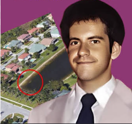
In August 2019, the disappearance of William Moldt was finally solved more than 22 years after he vanished from Lantana, Florida. The breakthrough came not from a new witness or forensic evidence, but from an unlikely source: Google Maps satellite imagery.
Moldt disappeared on November 7, 1997, after leaving a nightclub. According to investigators, he called his girlfriend to say he was on his way home, but he never arrived. Despite extensive efforts over the years, neither he nor his white Saturn SL sedan could be found, and the case gradually went cold.
The mystery took an unexpected turn when a former resident browsing Google Maps noticed what appeared to be the outline of a vehicle submerged in a pond behind a residential neighborhood in Wellington, Florida. Curious about the unusual shape visible in the satellite image, the observer alerted the property’s current resident, who flew a drone over the pond to get a closer look. The drone footage appeared to confirm that a car was resting beneath the water’s surface.
Authorities were notified and recovered the submerged vehicle. Inside, they found Moldt’s remains, bringing a heartbreaking mystery to an end after more than two decades. Investigators concluded that he had most likely accidentally driven into the retention pond shortly after leaving the nightclub in 1997. The surrounding area was far less developed at the time of his disappearance, and as new homes and roads were built over the years, the pond became part of a residential community while the vehicle remained hidden underwater.
Remarkably, the car had been sitting in relatively shallow water for decades. However, dense vegetation, changing water conditions, and the pond’s location meant it went unnoticed until higher-resolution satellite imagery made its outline visible from above.
The case quickly gained worldwide attention because it demonstrated how modern technology can unexpectedly assist in solving long-standing mysteries.